Wildfire News
‹ All PostsWhen Wildfires Make Their Own Weather
Weather normally helps determine how a wildfire behaves.
Wind can accelerate a fire front. Atmospheric instability may intensify a rising smoke column. Humidity and temperature can influence how readily vegetation burns.
Under exceptional conditions, however, the relationship can become two-way.
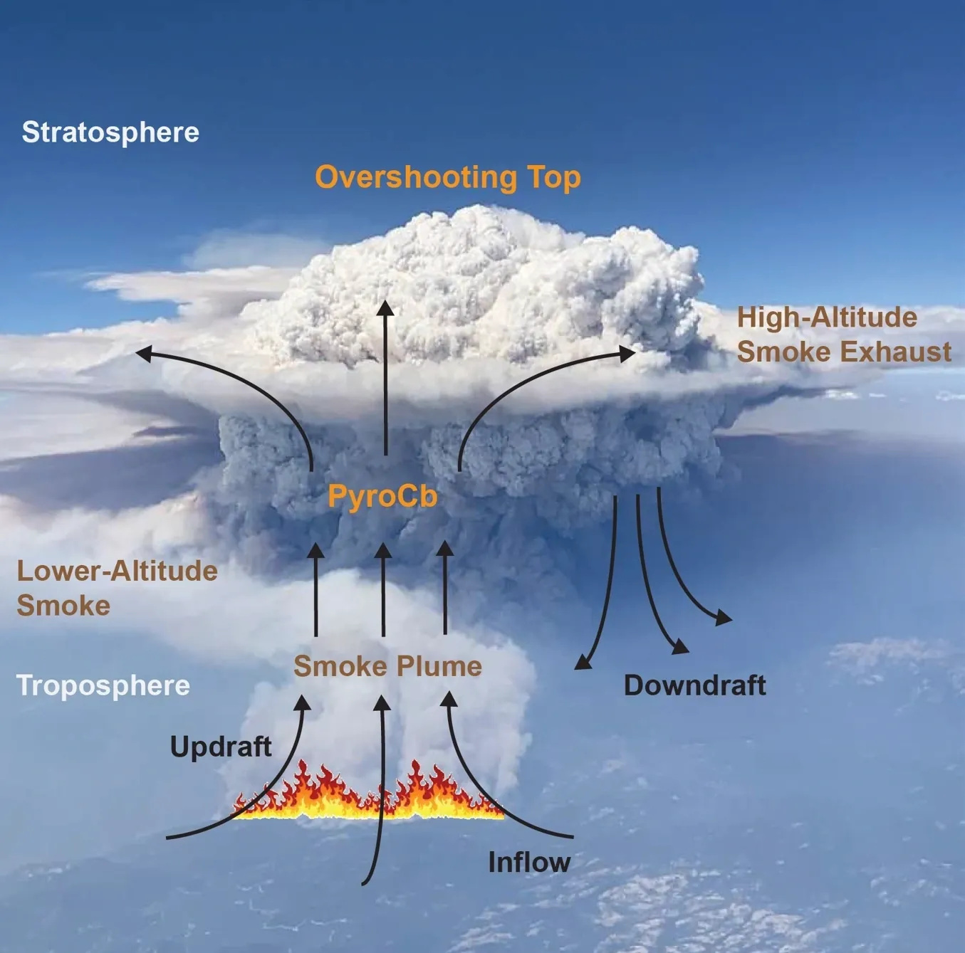
An intense wildfire can generate so much heat and vertical movement that its smoke column develops into a deep convective cloud. If that cloud reaches sufficient atmospheric depth and develops thunderstorm characteristics, it becomes a pyrocumulonimbus, commonly shortened to pyroCb.
A pyroCb is more than a tall plume. It is a wildfire-generated thunderstorm capable of changing the environment in which firefighters, pilots, communities and incident commanders are already operating.
That is the phenomenon NASA and the US Naval Research Laboratory are studying through the Injected Smoke and PYRocumulonimbus Experiment, or INSPYRE. The active airborne campaign brings together research aircraft, ground observations, satellite information and atmospheric modelling to investigate why some fires produce these storms, why some inject smoke into the stratosphere and what happens after that smoke reaches the upper atmosphere. NASA Jet Propulsion Laboratory
What is a pyrocumulonimbus storm?
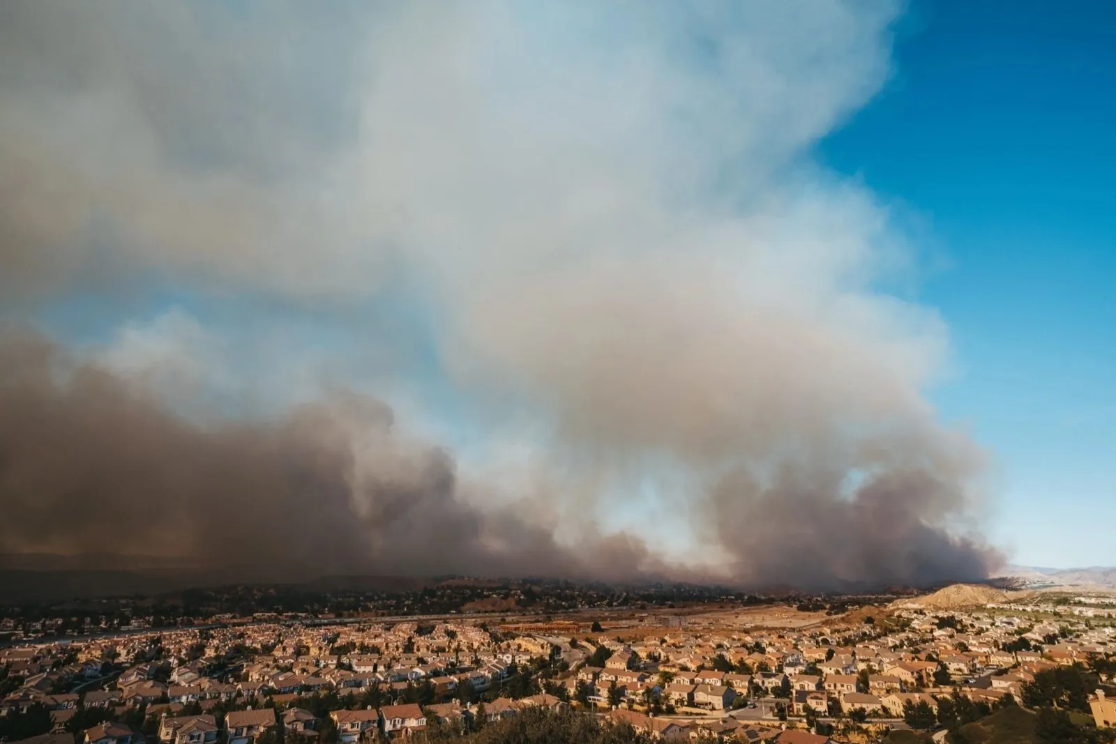
An intense wildfire releases heat that drives air, smoke and moisture upwards.
As the rising air cools, water vapour may condense and create a fire-generated cumulus cloud known as pyrocumulus, or pyroCu. These cloud-capped smoke columns are associated with vigorous convection above the fire.
Only a relatively small proportion continue developing into pyrocumulonimbus storms. A pyroCb reaches much higher, develops an ice-capped cumulonimbus structure and displays characteristics associated with severe convection. The transition from pyroCu to pyroCb remains incompletely understood and is one of the reasons dedicated field research is needed. Nature
The word “firestorm” is sometimes used in public discussion, but it can be ambiguous. Pyrocumulonimbus is the more precise term for this particular coupling of intense wildfire and thunderstorm development.
It should not be confused with:
- an ordinary smoke plume;
- a fire whirl or so-called fire tornado;
- a conventional thunderstorm that happens to be near a fire;
- or a historical urban firestorm.
These phenomena may occur in related environments, but they are not interchangeable.
Why these storms matter at the fireline
A pyroCb can introduce several hazards into an already complex wildfire environment.
Documented events have involved strong updrafts and downdrafts, rapidly changing winds, lightning, hail, obscured visibility and sudden changes in fire spread. Lightning generated within the cloud may also ignite new fires away from the original perimeter, although the amount of lightning varies substantially between events. Naval Research Laboratory
The danger is not that every pyroCb produces every possible hazard.
The danger is uncertainty.
A response operation may begin under one set of assumptions about winds, visibility and fire movement. Deep convection can then change several of those conditions together.
Smoke and cloud may obscure the fire below. Strong vertical air movement may complicate aviation. Outflow winds can alter local conditions. Lightning may introduce new ignition concerns. The visible fire perimeter may no longer represent the complete area requiring operational attention.
When an extreme wildfire begins generating its own thunderstorm, the operating environment is no longer static. Wind, lightning, smoke and aviation risk can change together, demanding current information and accountable human command.
What NASA’s INSPYRE mission is studying
INSPYRE is led by the US Naval Research Laboratory under NASA’s Earth Venture Suborbital programme. Research meteorologist David Peterson is the principal investigator, and more than 100 researchers from government agencies, universities and scientific organisations are involved. The programme includes field deployments in 2026 and 2027, followed by several years of analysis and scientific publication. Naval Research Laboratory
The campaign combines several layers of observation:
- high-altitude remote sensing;
- measurements collected by a Gulfstream research aircraft;
- ground-based observation;
- satellite information;
- and atmospheric modelling.
NASA’s ER-2 observes the evolving systems from high altitude, while another research aircraft and ground teams collect complementary measurements. The purpose is not to suppress the fires. It is to capture the physical and atmospheric processes that ordinary operational observations may not fully resolve. NASA Jet Propulsion Laboratory
NASA’s official campaign schedule shows that research flights and field observations were already taking place during early August 2026. The field campaign remains active, but full scientific conclusions will require analysis beyond the flights themselves. ESPO
The three questions scientists are trying to answer
INSPYRE is organised around three central scientific questions.
Why do some fires produce pyrocumulonimbus storms?
Many wildfires create substantial heat and smoke. Far fewer develop into deep, wildfire-generated thunderstorms.
Researchers are examining the combined influence of the fire, smoke column, moisture and surrounding atmospheric conditions. The objective is to understand which factors distinguish a large smoke plume or pyrocumulus cloud from a full pyroCb.
What controls high-altitude smoke injection?
Some pyrocumulonimbus storms lift smoke into the upper troposphere. Exceptional events can inject it directly into the lower stratosphere.
INSPYRE is studying what determines whether direct stratospheric injection occurs and how large the resulting high-altitude plume becomes.
What happens after the smoke reaches the upper atmosphere?
Once smoke enters the upper troposphere or stratosphere, it may remain aloft and travel far from the source.
Researchers want to understand how these plumes affect upper-atmospheric composition and Earth’s radiation balance. ESPO
These are scientific questions. They are not yet a set of operational rules that can identify precisely when every pyroCb will form or predict exactly how each storm will behave.
A wildfire can alter its own operating environment
Traditional wildfire planning often treats weather as an external force acting upon the fire.
PyroCb events demonstrate that, during exceptional fire behaviour, the fire and atmosphere may become closely coupled.
The fire provides intense heat and smoke to the developing cloud. Convective processes within the cloud can then produce strong vertical movement, inflow, outflow and other atmospheric changes around the fire.
Peer-reviewed research describes this as a feedback involving the fire, smoke, cloud and surrounding atmosphere. Yet the transition into this state—and its timing and consequences—remains difficult to characterise reliably. Nature
This creates an important systems lesson.
Wildfire-response planning should not assume that the conditions surrounding an incident will remain stable merely because the original perimeter, wind forecast or initial operational picture was understood.
Information must be capable of being updated. Decisions may need to be reconsidered. Airspace conditions can change. Capabilities that were suitable earlier may become inappropriate later.
Lightning and wind add operational uncertainty
Lightning is one of INSPYRE’s central research themes.
Some pyroCb storms generate extensive lightning. Others generate comparatively little. Scientists know that lightning can produce additional ignitions, but the reasons for the differences between storms remain uncertain. Naval Research Laboratory
Wind presents another difficulty.
Strong updrafts draw air into the convective column. Downdrafts and outflow may then produce changing surface conditions. These processes can affect fire movement, smoke distribution and the environment in which ground and aerial teams operate. Nature
The responsible conclusion is not that pyroCb behaviour is wholly unpredictable.
It is that existing understanding is incomplete and that operators should not treat one observation as a permanent description of the incident.
Aviation faces a different hazard picture
Wildfire aviation already operates in demanding conditions.
Smoke can reduce visibility. Several aircraft may be working within controlled incident airspace. Winds may vary across terrain and altitude. Ground personnel and aircraft must remain coordinated through authorised command.
A developing pyroCb adds cloud, strong vertical air movement, lightning and rapidly changing atmospheric conditions. NASA notes that these storms can create visibility and situational-awareness problems for aviators, while the scientific literature documents powerful updrafts, downdrafts and other severe convective hazards. NASA Jet Propulsion Laboratory
This does not mean that every aerial operation must end whenever a fire-generated cloud appears.
Nor does a research flight imply that ordinary firefighting aircraft should enter such an environment.
Specialised scientific missions operate under dedicated planning, aviation-authority approval, professional crews and risk controls. Operational firefighting decisions remain the responsibility of authorised aviation and incident-command professionals.
Smoke may reach the stratosphere
Most wildfire smoke remains within the lower atmosphere, where weather systems, mixing and precipitation help determine how it moves and eventually disperses.
Exceptional pyrocumulonimbus events can act like powerful atmospheric chimneys, lifting smoke into the upper troposphere or lower stratosphere. Once smoke reaches the stratosphere, it may travel widely and persist much longer than smoke confined to the lower troposphere. NASA Science
Some particularly large events have injected smoke on a scale compared in scientific literature with moderate volcanic eruptions. That comparison applies to exceptional smoke injection—not to every pyroCb. NASA Science
NASA’s research is examining potential effects on:
- atmospheric composition;
- long-range smoke transport;
- radiation;
- stratospheric circulation;
- and the representation of pyroCb processes in Earth-system models.
The purpose is not only to understand what happens above the fire. It is to understand consequences that may continue long after the immediate incident.
Research is not yet an operational forecast
The distinction between scientific research and operational forecasting is essential.
INSPYRE is designed to collect observations that may eventually help improve how scientists and operational agencies monitor and forecast pyrocumulonimbus development. NASA describes the mission as filling gaps in current observations and models. NASA Jet Propulsion Laboratory
That does not mean NASA can now predict precisely:
- which fire will generate a pyroCb;
- the exact time development will begin;
- how much lightning will occur;
- whether smoke will enter the stratosphere;
- or how the storm will affect each response operation.
A reliable operational warning requires more than recognising favourable conditions. It requires validated models, dependable observations, tested interpretation and integration into authorised forecasting and emergency-management structures.
INSPYRE is helping build the scientific evidence for that future capability.
Response readiness must adapt to changing conditions
Pyrocumulonimbus storms reinforce a broader principle of wildfire readiness: response systems should be designed for changing conditions rather than a static incident.
At a strategic level, that requires attention to:
- current operational awareness;
- safe field positioning;
- airspace coordination;
- resource availability;
- changing weather and smoke;
- continuing assessment;
- documented decisions;
- and authorised human supervision.
This does not require every organisation to share every piece of data.
It requires the correct information to reach the authorised people who need it, in a form that supports professional judgement.
More information alone is not the answer. Information must be current, relevant, understandable and connected to responsibility.
Every intervention should improve understanding
A suppression or observation action should contribute to the next authorised decision.
After an intervention, operators may need to know whether conditions changed, what remains uncertain and whether additional attention is required.
In a rapidly evolving atmospheric environment, that assessment becomes especially important. A decision based on conditions from an earlier stage of the incident may no longer remain appropriate.
The public principle is straightforward:
Action should connect to assessment, and assessment should support accountable next steps.
The detailed methods by which an individual platform or authority performs that assessment are operationally and commercially sensitive and are not addressed here.
Human command remains central
Scientific observations, meteorological forecasts and emerging autonomous capabilities all require responsible interpretation.
Wildfire operations affect communities, airspace, responders, infrastructure and public resources. Decisions must remain within:
- authorised incident command;
- aviation regulation;
- professional meteorological interpretation;
- responder-safety requirements;
- applicable law;
- and human accountability.
Technology should not independently decide that aircraft can enter a hazardous convective environment. It should not determine which community receives priority or override emergency-command structures.
Its role is to support authorised professionals—not replace responsibility.
The PRAESI perspective
PRAESI is developing a patented integrated wildfire-response system bringing together field deployment, autonomous aerial suppression, sensing, operator oversight and repeatable response workflows. Its public materials describe these capabilities at a high level and state that deeper technical, deployment and intellectual-property details remain under controlled disclosure. PRAESI Technologies Ltd
PRAESI is not part of NASA’s INSPYRE campaign.
It does not claim current integration with NASA, the US Naval Research Laboratory, NOAA, the National Science Foundation or NCAR. It does not claim an operational pyrocumulonimbus-forecasting capability, the ability to operate within such storms or the ability to prevent their formation.
PRAESI also does not claim that its developing system would have changed the outcome of any wildfire discussed by NASA or The Economist.
The responsible connection is at the level of system design.
Pyrocumulonimbus storms show why wildfire response cannot assume that the environment surrounding a fire remains unchanged. A serious response architecture must account for uncertainty, changing conditions, operator visibility, assessment and human authority.
PRAESI’s public system concept connects field deployment, aerial capability, sensing, assessment, repeatable readiness and operator oversight as parts of one response chain rather than as disconnected technologies. It remains on a staged proof-build pathway. PRAESI Technologies Ltd
No proprietary implementation method, operational threshold or technical configuration is disclosed in this article.
Questions wildfire readiness should ask
- How is developing severe convection communicated to authorised responders?
- How are changing wind, smoke and visibility conditions reflected in the operational picture?
- How is aviation protected when a wildfire-generated storm develops?
- How are possible lightning ignitions distinguished from the original incident?
- How are observations from meteorologists, satellites, aircraft and fire authorities reconciled?
- How is the effect of each authorised action assessed?
- How is resource availability updated as conditions change?
- How are decisions and completed actions documented?
- How can new research move responsibly from observation to operational preparedness?
- How can emerging autonomous capabilities support authorised command without creating another disconnected layer?
These are planning questions, not criticisms of the firefighters, pilots, meteorologists or researchers confronting an exceptionally difficult phenomenon.
Conclusion
A wildfire is not always a passive feature beneath the weather.
Under exceptional conditions, it can generate a deep convective storm that changes the environment in which responders must operate.
Wind may shift. Lightning may introduce new ignition concerns. Smoke can obscure the incident and rise into the upper atmosphere. Aviation may face a substantially different hazard picture from the one that existed earlier.
NASA’s INSPYRE campaign is intended to improve scientific understanding of that transition.
It has not solved pyrocumulonimbus forecasting. It does not suppress fires. Its value lies in collecting observations that have rarely been available together and using them to improve future models, monitoring and preparedness.
Firefighters, pilots, incident commanders, meteorologists, atmospheric scientists, airspace authorities and emergency planners each see a different part of this problem.
Responsible innovation must connect those perspectives without confusing their roles.
No technology can eliminate extreme wildfire risk.
The objective should be better situational awareness, stronger assessment and more accountable human decisions when the fire environment changes.
A pyrocumulonimbus storm is a powerful reminder that the fireline is not always fixed—and neither is the atmosphere above it.
FAQ
What is a pyrocumulonimbus storm?
A pyrocumulonimbus, or pyroCb, is a deep wildfire-generated convective cloud that develops thunderstorm characteristics. It can form when extreme heat drives smoke, moisture and air high into the atmosphere. A pyrocumulus is a less-developed fire-generated cloud; only a relatively small proportion progress into pyroCb storms. Nature
Can a wildfire really create its own weather?
Under exceptional conditions, yes. An intense fire can generate strong convection and a thunderstorm-like cloud system. This may introduce lightning, powerful vertical air movement and changing winds around the fire. Not every wildfire creates these conditions. Naval Research Laboratory
Can pyrocumulonimbus lightning start new fires?
It can. Lightning from some pyroCb storms has been associated with new downwind ignitions. However, some pyroCbs produce substantial lightning while others produce comparatively little. Understanding that variation is one of INSPYRE’s research priorities. Naval Research Laboratory
What is NASA’s INSPYRE mission studying?
INSPYRE is studying why certain fires generate pyrocumulonimbus storms, what controls smoke injection into the upper atmosphere and how the resulting smoke affects atmospheric composition and radiation. The campaign combines aircraft, ground, satellite and modelling observations. ESPO
Can INSPYRE already predict these storms?
Not as a complete operational forecasting system. The mission is gathering observations intended to improve scientific understanding, monitoring and future forecasting. Its results will require analysis and validation after the field deployments. NASA Jet Propulsion Laboratory
PRAESI is developing a patented integrated wildfire-response system connecting field deployment, autonomous aerial suppression, sensing, assessment, repeatable readiness and operator oversight. PRAESI remains on a staged proof-build pathway and does not claim current pyrocumulonimbus forecasting or involvement in INSPYRE. PRAESI Technologies Ltd