Wildfire News
‹ All PostsSeptember 2026: The U.S. Fire Year Reached 8.56 Million Acres
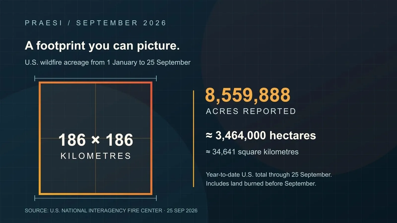
Image caption: The square is an area comparison for the 8,559,888 acres recorded by the U.S. National Interagency Fire Center from 1 January through 25 September 2026. It does not show the shape or location of any fire.
Imagine drawing a square 186 kilometres from one side to the other. It would cover roughly 34,600 square kilometres. That is the area equivalent of 8,559,888 acres, the U.S. National Interagency Fire Center’s recorded wildfire acreage from 1 January through 25 September 2026.
The figure is year-to-date, not an estimate of land newly burned in September. It covers one country, not the globe. The distinction matters. A monthly story can give a reader the wrong impression if it puts a September label beside a cumulative number without explaining the clock.
A season still growing in September
By 25 September, NIFC counted 57,087 U.S. wildfires since 1 January. At the same point in 2025, the agency had recorded 52,112 fires and 4,489,828 acres. The 2026 acreage stood at 145% of the ten-year average for that date. These comparisons use the same point in each year, which is more useful than comparing a partial year with a finished one. NIFC National Fire News, 25 September 2026.
The report also described thousands of personnel assigned to incidents while most current fires showed minimal to moderate behaviour. Holding lines, checking heat and making the ground safe all take time after the dramatic images disappear.
The number needs care. Acres burned says little on its own about which homes, roads or water supplies were exposed. The comparison square helps a reader grasp scale; it cannot map risk.
September did not look the same everywhere
Across the Atlantic, the European Commission’s Joint Research Centre reported 678,978 hectares affected by fires in the EU by 23 September. That was below the area recorded by the same date in 2025, but above the 2006–2025 average of 355,397 hectares. This is another year-to-date figure, produced with a different mapping method from NIFC’s. The two numbers should not be added together as a September total. JRC wildfire situation, 23 September update.
In Southeast Asia, fire’s footprint was measured in air as well as land. Singapore’s National Environment Agency said on 9 September that moderate to dense plumes from Sumatra and Kalimantan were drifting towards the city. Its 24-hour Pollutant Standards Index was then 74–98, in the Moderate range, with a High Moderate to Low Unhealthy forecast. A person far from the fireline can still have to change an ordinary day because of smoke. NEA haze update, 9 September.
Colombia offered a much smaller area with an immediate local consequence. By 21 September, a fire near Villa de Leyva had affected about 290 hectares and prompted evacuations, according to the Pan American Health Organization’s monitoring note citing Colombia’s disaster agency. The event is a reminder that a ranking by hectares does not rank the danger to people. PAHO/WHO natural hazards monitoring, 21 September.
What the figures leave out
A monthly review compresses very different stages of a fire into one line. The area may have grown in August, held steady in September and still required September crews. Smoke can cross a border while the flames stay inside one province. A short-lived fire near a town can call for urgent action even when its footprint is small.
That is why the PRAESI view of readiness starts before an incident and continues after the first alert. Detection has to reach an operator quickly enough to matter. Response equipment has to be available, directed and replenished. Local agencies need a clear picture of what remains at risk when the headline acreage stops changing.
PRAESI is developing a wildfire-response system connecting sensing, autonomous aerial suppression and operator oversight. These September reports do not describe a PRAESI deployment. The system’s effectiveness must be demonstrated through testing and operational validation. The point of this review is to keep the operational problem in view: fire is not over merely because its growth slows.
Frequently asked questions
Did 8.56 million acres burn in September? No. NIFC’s figure counts U.S. wildfire acreage from 1 January to 25 September 2026.
Is the square a map of the fires? No. Converting 8,559,888 acres gives about 34,641 square kilometres. A square of that area has sides of about 186 kilometres. The fires were separate incidents in different states.
Can this figure be added to August’s PRAESI total? No. The August article selected North American incidents and used cumulative incident footprints. This U.S. year-to-date count includes earlier months, including August, and uses a different method.
Why include Europe, Indonesia and Colombia without adding their areas? Their data use different definitions and observation dates. They show what September demanded of responders and communities, but do not form one comparable global total.
Sources and methodology
Prepared using information available through 25 September 2026. The headline area comes from NIFC’s year-to-date statistic for 1 January–25 September: 8,559,888 acres × 0.40468564224 = 3,464,064 hectares, or 34,641 square kilometres; the equivalent square has sides of 186.12 kilometres, rounded to 186. U.S. fire counts and year-to-date comparisons come from the same NIFC report. The EU, Singapore and Colombia examples retain their own dates and reporting scopes. Figures may change as agencies revise perimeters and records. No global September burned-area estimate is claimed.