Wildfire News
‹ All PostsJuly 2026: Fifteen Major Wildfires Spanned Nearly Size of Kuwait
Fifteen wildfire incidents. Five countries. A combined reported area so large that familiar comparisons struggle to convey it.
The 15 largest verified wildfire incidents active during July 2026 covered approximately:
- ** 1,739,545 hectares**
- ** 17,395 square kilometres**
- ** 4.30 million acres**
- ** 97.6% of Kuwait’s total area**
- ** 1.88 times the size of Cyprus**
Kuwait covers approximately 17,818 square kilometres, while the total area of Cyprus is approximately 9,251 square kilometres. The comparison therefore places the combined Top 15 perimeter just short of Kuwait’s entire territory and at nearly twice the area of Cyprus.
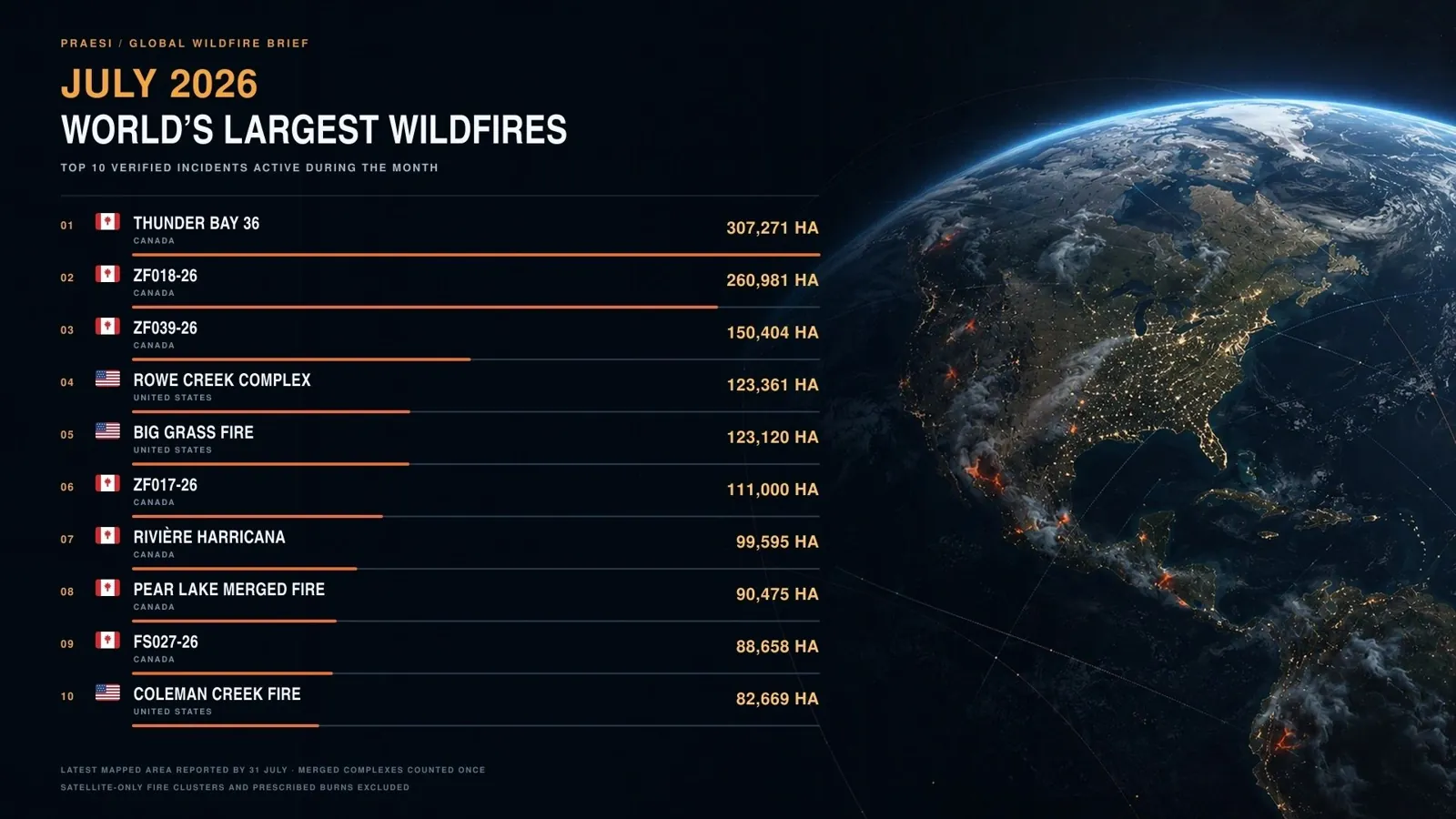
The Top 10 incidents shown in the accompanying visual alone total 1,437,534 hectares, or approximately 14,375 square kilometres. That is around 4% larger than Montenegro, whose official land area is approximately 13,812 square kilometres.
These comparisons are not intended to sensationalise wildfire loss. They provide scale for a dataset that would otherwise remain difficult to visualise.
Most importantly, the figure of 1.74 million hectares is not the total area burned by every wildfire worldwide during July.
It is the defensible combined total of the 15 largest individually verified incidents that were active during the month.
Key insight: The combined size of July’s largest incidents does not merely demonstrate how far fire travelled. It shows how long multiple response systems had to remain active, distributed and accountable across several jurisdictions at the same time.
How this ranking was built
This revised analysis uses a different and broader test from a ranking limited to fires that first ignited in July.
An incident qualified if it was active at any point during July 2026, regardless of whether it began during the month or remained active as a carryover from June.
The ranking therefore includes:
- fires that started during July;
- fires that began earlier but remained active during July;
- officially named merged incidents;
- and recognised fire complexes whose perimeters were reported as one managed incident.
The reported area for each incident is the latest defensible figure available at the 31 July 2026 editorial cutoff.
That leads to an essential qualification:
The combined figure represents the reported incident perimeters by 31 July. It does not mean that all 1,739,545 hectares burned exclusively between 1 and 31 July.
Some carryover incidents had already accumulated part of their area before the month began. Conversely, several fires continued changing after the cutoff.
The methodology also prevents double counting. Once component fires became part of an officially reported merged fire or complex, they were not ranked again as separate incidents.
The geography of July’s largest fires
The ranking was heavily concentrated in Canada and the United States.
The largest incidents included major fires and complexes across:
- northwestern Ontario;
- the Northwest Territories;
- British Columbia;
- Oregon;
- Idaho;
- Washington;
- Spain;
- and Russia’s Sakha Republic.
This concentration does not mean other regions experienced no meaningful wildfire activity.
Cyprus, Africa, Oceania, South America and other parts of Europe recorded fires, alerts or significant seasonal conditions. However, no individually verified incident from those regions exceeded the threshold required to enter this specific Top 15 dataset at the July 31 cutoff.
Nor does the ranking establish total global wildfire activity by region. It measures named or traceable incident-level perimeters, not every satellite-detected burn, smaller incident or nationally aggregated area.
The conclusion should therefore remain precise:
The largest individually verified incidents active during July 2026 were overwhelmingly concentrated in northern and western North America.
Canada carried the largest share of the ranked area
Canada’s presence in the ranking was driven by several exceptionally large incidents, including:
- Thunder Bay 36 in northwestern Ontario;
- ZF018-26, ZF039-26, ZF017-26 and FS027-26 in the Northwest Territories;
- Rivière Harricana in Québec;
- the Pear Lake merged fire in British Columbia;
- and FS038-26 in the Dehcho Region.
Several of these incidents burned in remote or sparsely populated terrain.
That does not make them operationally insignificant.
Remote wildfire environments may create different pressures from fires near major cities:
- long mobilisation distances;
- limited road access;
- reliance on aviation;
- difficulties maintaining current perimeter information;
- smoke affecting distant communities;
- and the need to coordinate across provincial, territorial, federal and Indigenous jurisdictions.
A large remote fire may expose fewer structures than a smaller fire at an urban edge. It may nevertheless remain active for longer, occupy substantial monitoring capacity and affect communities far beyond its perimeter through smoke and transport disruption.
The western United States faced several large incidents at once
The United States entries were concentrated primarily across Oregon, Idaho and Washington.
Among the largest were:
- the Rowe Creek Complex;
- the Big Grass Fire;
- the Coleman Creek Fire;
- the Hay Creek Complex;
- and the Kaiser Canyon Fire.
Their significance lies not only in their individual sizes.
Several large incidents occurring within the same broad geographic period create simultaneous demand for:
- aircraft;
- firefighters;
- incident-management personnel;
- engines and heavy equipment;
- logistical support;
- maintenance;
- communications;
- road access;
- and relief crews.
A jurisdiction may possess substantial resources and still face pressure when those resources are already assigned.
This is why operational capacity cannot be measured only by the number of aircraft, vehicles or personnel listed on paper.
The more important questions are:
- Which assets are genuinely available?
- Which are already committed?
- Which are returning from another assignment?
- Which are undergoing necessary checks or servicing?
- Which crews require rest?
- Which capabilities are suitable for the next incident?
- And what reserve remains if another fire begins?
Burned area is not the same as human consequence
A global ranking by hectares needs careful interpretation.
A larger burned area does not automatically mean:
- more deaths;
- more evacuations;
- more homes destroyed;
- greater ecological severity;
- greater financial loss;
- or poorer firefighting performance.
A remote 200,000-hectare fire may cause less direct structural damage than a 5,000-hectare fire moving through a populated settlement.
Different parts of the same perimeter may also burn at different levels of severity.
Acreage cannot independently reveal:
- fire intensity;
- vegetation loss;
- community exposure;
- Infrastructure interruption;
- smoke-related health effects;
- or how much larger the incident might have become without intervention.
The Top 15 should therefore be understood as a ranking of geographic scale, not a competition between disasters.
Large perimeters expose a deeper response problem
The 1.74 million-hectare total represents more than land within fire boundaries.
It represents sustained demand placed on multiple emergency systems.
A long-duration wildfire campaign may require authorities to maintain:
- awareness of several evolving incidents;
- clear responsibility across jurisdictions;
- operational visibility over committed resources;
- continuity as teams rotate;
- safe aviation coordination;
- repeatable asset readiness;
- reliable public information;
- and documented human decision-making.
The visible suppression action is only one part of that requirement.
Wildfire response also depends on everything before and after the action:
- whether the incident was detected quickly;
- whether authorised capability was positioned close enough to matter;
- whether the response could be sustained;
- whether the effect of an intervention was understood;
- and whether resources could safely become available again.
These are system-level challenges.
They cannot be solved by treating a sensor, aircraft, vehicle or software platform as an isolated answer.
Operational availability matters more than nominal fleet size
A country may own or contract a substantial number of aircraft and still face limited immediate availability.
An asset may be:
- committed to another incident;
- travelling between operating locations;
- awaiting a qualified crew;
- undergoing inspection or servicing;
- affected by weather or visibility;
- or unsuitable for the role required at that moment.
The same is true of ground personnel and command teams.
Capacity should therefore be understood as a dynamic condition rather than a fixed inventory.
An effective operating picture needs to distinguish between:
- assets that exist;
- assets that are serviceable;
- assets that are staffed;
- assets that are positioned;
- assets that are committed;
- and assets that are genuinely ready for authorised use.
This distinction becomes especially important when several large fires remain active at once.
Vast territories make field positioning important
The July ranking spans some of the world’s largest and most difficult operating environments.
Remote northern Canada, the Pacific Northwest, inland Oregon and Siberia involve very different landscapes, authorities and response models. Yet each raises a common strategic question:
How close is usable, authorised response capability when an incident begins or changes?
Long travel distances can reduce the practical value of an otherwise capable asset.
Field positioning may help reduce avoidable mobilisation delay. It may also support more consistent local readiness during periods of elevated danger.
This does not mean placing identical resources in every location.
It means designing layered capability around:
- geography;
- forecast risk;
- access;
- community exposure;
- infrastructure;
- authorised command;
- and the role of existing national or regional assets.
Sustained readiness depends on repeatability
A response system should not be evaluated only by whether it can perform one visible action.
Long-duration incidents require capability that can remain useful over time.
At a public and non-operational level, this means considering whether assets and teams can:
- complete an authorised assignment;
- return safely;
- restore readiness;
- be reassessed;
- receive further authorised direction;
- and support another response where appropriate.
The detailed implementation of such a cycle is sensitive and system-specific. It should not be disclosed through public editorial material.
The principle, however, is clear:
A one-time intervention is not the same as sustained response capacity.
When multiple fires remain active across different jurisdictions, repeatability becomes one of the defining measures of readiness.
Every action should improve operational understanding
Suppression activity should contribute to the next authorised decision.
After an intervention, responsible operators may need to understand:
- whether conditions changed;
- what uncertainty remains;
- whether further attention is required;
- and which resources remain available.
This does not require public disclosure of technical verification logic or proprietary operating methods.
It requires recognition that action without sufficient assessment can leave decision-makers with incomplete information.
During a multi-incident period, uncertainty at one fire can affect resource decisions elsewhere.
The purpose of assessment is therefore not merely to produce a later report. It is to support clearer, accountable human judgement throughout the response.
Human authority must remain central
Wildfire response involves decisions affecting communities, responders, airspace, infrastructure and public resources.
Those decisions must remain within:
- authorised incident command;
- civil-protection structures;
- applicable law;
- responder-safety requirements;
- aviation controls;
- and accountable human supervision.
Autonomous or remotely operated capabilities should not independently determine which community, incident or asset receives priority.
Technology may support authorised professionals by improving information, readiness or repeatability.
It must not replace legal responsibility or professional judgement.
That principle becomes more important as system capability increases.
The PRAESI perspective
PRAESI is developing a complete wildfire-response system designed to bring together field deployment, autonomous aerial suppression, sensing, operator oversight and repeatable response workflows.
Its public positioning treats those elements as one coordinated response system rather than as isolated aircraft, drones, sensors or software products. PRAESI’s public materials also state that deeper technical, intellectual-property, partner-integration and deployment information is available only through controlled disclosure.
PRAESI was not involved in any incident included in this ranking.
It does not claim that its developing system would have prevented the fires, eliminated the reported acreage or replaced the professional responders involved.
The relevance of the July dataset lies instead in the questions it raises:
- How can response capability be distributed closer to wildfire risk?
- How can authorised operators distinguish nominal resources from genuine availability?
- How can a response remain useful through a prolonged incident?
- How can several concurrent commitments remain visible and accountable?
- How can emerging capabilities complement established national and regional systems?
- And how can the entire process remain under responsible human command?
PRAESI’s public discussion remains intentionally high-level. No proprietary architecture, implementation method, operational logic, technical specification or replicable deployment configuration is disclosed in this article.
The central proposition is simpler:
Wildfire response should operate as an organised and accountable system—not as a collection of disconnected tools.
Questions global wildfire readiness should ask
The July 2026 ranking raises several strategic questions:
- How many large concurrent incidents can a jurisdiction sustain?
- Which assets are genuinely available rather than nominally listed?
- Where should authorised capability be positioned during elevated-risk periods?
- How are long travel distances reflected in readiness planning?
- How are merged fires and complexes reported without double counting?
- How are remote incidents monitored when public reporting is limited?
- How is responder endurance protected during prolonged campaigns?
- How does each authorised action contribute to clearer understanding?
- How quickly can resources safely restore readiness?
- How are cross-jurisdiction requests coordinated?
- How are decisions and completed actions preserved for review?
- How can emerging technologies support established command without adding another disconnected operational layer?
These are not criticisms of the authorities or responders involved.
They are the questions revealed when 15 major incidents collectively span an area approaching the size of an entire country.
Conclusion
The 15 largest verified wildfire incidents active during July 2026 covered approximately 1.74 million hectares by the month-end cutoff.
That is:
- almost the total area of Kuwait;
- nearly twice the size of Cyprus;
- and more than four million acres.
The Top 10 alone covered an area slightly larger than Montenegro.
Yet the meaning of the ranking lies beyond the comparison.
These incidents required firefighters, aviation crews, dispatchers, land-management organisations, Indigenous and tribal partners, local authorities, emergency personnel and affected communities to operate across enormous distances and over prolonged periods.
Acreage alone cannot measure their success.
Technology cannot eliminate wildfire risk.
One aircraft, one sensor or one intervention cannot solve a distributed global response problem.
Readiness depends on whether authorised people and capabilities can remain available, coordinated, informed and accountable while several incidents continue at the same time.
That is what July 2026’s geography ultimately reveals.
The largest fires do not test suppression power alone.
They test the endurance of the entire response system.
FAQ
What was the combined area of the 15 largest verified wildfire incidents active during July 2026?
The 15 incidents had a combined reported perimeter of approximately 1,739,545 hectares, equivalent to around 17,395 square kilometres or 4.30 million acres.
This is not the total area burned by every wildfire worldwide during July.
How does that area compare with Cyprus?
Cyprus covers approximately 9,251 square kilometres. The Top 15 total was therefore approximately 1.88 times the area of Cyprus.
How does it compare with Kuwait?
Kuwait covers approximately 17,818 square kilometres. The Top 15 total was equivalent to approximately 97.6% of Kuwait’s total area.
Why does the article say “active during July” rather than “started during July”?
The broader methodology includes large fires that began before July but remained active during the month. This better reflects the response capacity already committed when July began.
Did all 1.74 million hectares burn during July alone?
Not necessarily. The figure combines the latest reported perimeters of incidents active during July. Some carryover fires had already accumulated part of their area before 1 July.
Does a larger fire automatically mean a more destructive fire?
No. Burned area does not independently measure fatalities, evacuations, structural loss, ecological severity, infrastructure disruption or economic damage. Smaller fires near populated areas may have more severe human consequences.
Which PRAESI geographic category dominated the ranking?
The primary category was 3 — Americas & Caribbean, driven by the concentration of major fires in Canada and the western United States.
Europe and Asia & Middle East were also represented.
What is PRAESI developing?
PRAESI is developing a patented integrated wildfire-response system bringing together field deployment, autonomous aerial suppression, sensing, operator oversight and repeatable response workflows.
The system remains on a staged proof-build pathway, and sensitive technical or deployment information is maintained under controlled disclosure.